Close
Manufacturer
Pieter PourbusPeriod and date
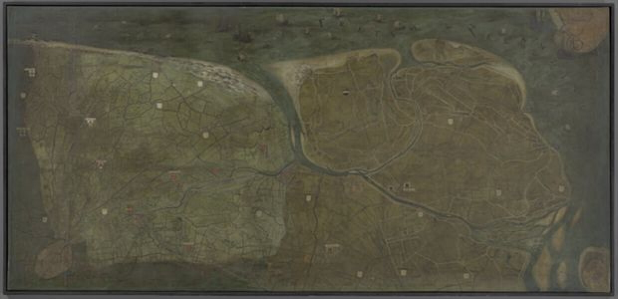
16de eeuwOf the total surface of the original topographical map of the castellanies of the Liberty of Bruges that Pourbus finished in 1571, only a fourth survives. The remaining fragment shows the northeastern part of the territory of the liberty of Bruges, from Bruges to Zeeland. The identification of the map was possible thanks to a surviving copy (0000.GRO0438.I) that Pieter Claeissens made as early as 1596-1597 after the already severely damaged original by Pourbus. The copy shows us the territory between the Yser river and the Western Scheldt. Its inscription, partially copied from the original map, states that the different cities, villages, hamlets, inns, channels, water dikes, etc., are marked by individual colours. The original map by Pourbus was the biggest (23,58 m²) and one of the most accurate maps of its time. Due to the presence of 35 crests, representing guilds, cities and manors, the map is also of heraldic interest. This fragment does not only show the most densely populated and complex parcelled area but is also the most accurate cartographic document of the Zwin region during the late-medieval period.
TOPSTUK
For 10 years, from 1561 – 1571, Pourbus worked on the map of the Liberty of Bruges. Because of archival documents, relatively much is known about the monumental task and the payment Pourbus received for his labour, but it is difficult to reconstruct his working methods. Due to the size of the map, Pourbus most likely produced smaller preparatory maps beforehand, sometimes copied after existing maps, and sometimes based on his own measurements. We know that Pourbus regularly spent consecutive days doing fieldwork. He most likely went up towers, such as the Belfry of Bruges, to make sketches of the surroundings that he would later work up in his workshop. He also used orthogonal projection and triangulation. The latter method was at the time recently published (1545) by the mathematician Gemma Frisius. With triangulation, mathematical calculations and instruments such as a quadrant are used to measure the distance to certain landmarks (such as towers), a method that Pourbus clearly had mastered. Contemporary and writer Karel van Mander therefore deservedly describes Pourbus as a gifted ‘cosmographus oft landmeter’ (cartographer or land surveyor) in his Schilder-boeck of 1604.